


 ENG
ENG
Thermal Mapping of roads
For timely and good preparation of preventive measures, the highway maintenance service requires a forecast of winter slipperiness 4 hours in advance. These forecasts should take into account typical peculiarities of some road segments. For a more detailed forecasting of weather conditions over the entire road network and not only at some parts where the RWS are installed, and correspondingly for minimizing the costs of consumption of chemical reagents and the environmental impact, thermal mapping is performed.
Thermal mapping is determination of spatial temperature variations of the road surface and their presentation in the form of statistically processed database. The highway surface temperature variations in the wintertime may comprise up to 10 degrees over the segment with a length of about 100 km. These changes are connected with such factors as terrain relief, bridges, roadbed structure, thermal (urban buildings) and water (water reservoir, river, sea, etc.) sources. Most of these factors are fixed in space, and due to this, result in recurring distribution relative to warm and cold segments under the equal weather conditions and have, correspondingly, a systematic character. Thermal mapping is based on the established fact that the distribution of spatial surface temperature variations is repeated in a stable way during the winter period at similar weather conditions.

In IRAM, a special mobile laboratory was created on the basis of the Volksvagen Transporter T5 for performing thermal mapping. For the last three years, thermal mapping is made at different highways with a total length of more than one thousand five hundred kilometers.
Tasks
Functions performed
Examples of the forecast of surface temperature and state for 4 hours
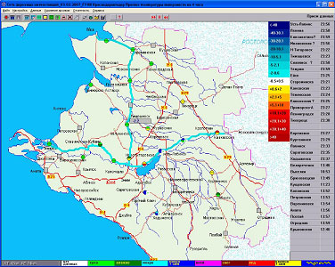
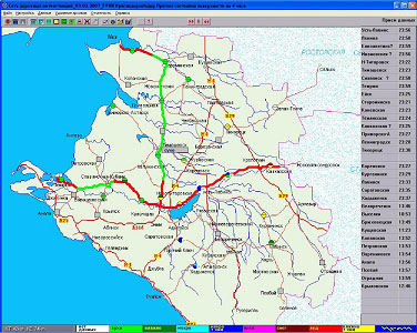
The results of thermal mapping are used in the automated system of meteorological support of highways for operation in the mode of «virtual stations». For application of thermal mapping data under the operational conditions the database of digital thermal maps is connected to the functioning AIMS «MeteoRoute». Using surface temperature data at the locations of RMS installation and thermal maps for the corresponding weather conditions, the surface temperature values are calculated for a network of «virtual weather stations» and for the entire highway segment. Based on the forecast data for separate points – locations of road weather stations and forecast data of the network of virtual weather stations, formation of winter slipperiness is forecasted for the entire highway. Such forecasting technology is being tested at the SI KK «Krasnodaravtodor».
The forecast quality (skill score) significantly depends on the thermal mapping data volume. To improve the statistical significance of data it is necessary not only to expand the road network for thermal mapping, but also to increase the number of passages along the same routes under different weather conditions.